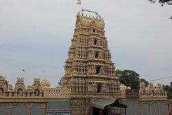
Thirumakudalu Narasipura
T. N. Pura | |
|---|---|
Town | |
| T. Narasipura | |
 Gunja Narasimha swamy temple, Narasipura | |
| Nickname: Temple City | |
 | |
| Coordinates: 12°12′36″N 76°54′22″E / 12.21°N 76.906°E | |
| Country | |
| State | Karnataka |
| District | Mysore |
| Elevation | 638 m (2,093 ft) |
| Population | |
| • Total | 31,498[1] |
| Languages | |
| • Official | Kannada |
| Time zone | UTC+5:30 (IST) |
| PIN | 571 124 |
| Telephone code | 08227 |
| Vehicle registration | KA-55 KA-09 |

Tirumakudalu Narasipura (Tirumakūḍalu Narasīpura) the temple city of Karnataka, commonly known as T. Narasipura or T.N. Pura,[2] is a town in Mysore district in the Indian state of Karnataka. The first name refers to the land at the confluence, (trimakuta in Sanskrit[citation needed] at the confluence of the Kaveri, Kabini and Spatika Sarovara (a mythical lake or spring, also named Gupta Gamini). The city is a Taluk of Mysore district and 32 km south-east of the district headquarters and has five Hobli centers. This taluk is bordered by Chamarajanagar district to the south and Mandya districts to the north with an area of 598 sq km. Agriculture is the main occupation of the people here. Rice is the main food crop and silk is the main commercial crop. Fossils of Neolithic age have been found by excavation in some lands of this Taluk.[3] Vyasatirtha, the guru of Purandara Dasa, and T Chowdiah, the unique violinist, were born in this Taluk. Talakad, the capital of the Western Ganga dynasty, is in this Taluk.
This is the place in South India where Kumbhamela is held every three years. It finds a mention in the Skanda Purana as one of the Trimakuta Kshetras (holy places at the confluence of three rivers).[4] The word 'Narasipura' is the name of the town, which is derived from the famous Gunja Narasimhaswamy temple that is located on the right bank of the Kabini (Kapila) river. Considered as sacred as Prayag (confluence of the Ganges, the Yamuna and the Saraswati at Prayag – Varanasi - Kashi in North India), it is also known as Dakshina Kashi The town finds mention in tourism guides, both as a tourist place and a pilgrimage centre.
- ^ Unknown[permanent dead link]
- ^ "Gram Panchayat and Taluk Boundary Map" (PDF). Archived from the original (PDF) on 9 April 2009.
- ^ "A Glance on Archaeological Remains of Karnataka" (PDF). www.jetir.org.
- ^ "Mysore". karnatakaholidays.com. Archived from the original on 14 January 2017. Retrieved 15 June 2008.