| Thornapple River | |
|---|---|
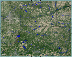
 Enhanced USGS Satellite Image, Thornapple River drainage basin. | |
 | |
| Native name | |
| Location | |
| Country | United States |
| State | Michigan |
| Counties | Drainage basin covers portions of Barry, Eaton, Ionia, and Kent Counties in Central Michigan |
| Physical characteristics | |
| Source | |
| • location | S of Boody Lake, Eaton Township, Eaton County, Michigan |
| Mouth | |
• location | Grand River, Ada Township, Kent County, Michigan |
• elevation | 617 ft (188 m)[2] |
| Length | 88 mi (142 km) |
| Discharge | |
| • location | mouth |
| • average | 838.49 cu ft/s (23.743 m3/s) (estimate)[3] |
The Thornapple River (Ottawa: Sowanquesake, "Forked River")[4] (GNIS ID #1075813[5]) is an 88.1-mile-long (141.8 km)[6] tributary of Michigan's longest river, the Grand River. The Thornapple rises in Eaton County, Michigan and drains a primarily rural farming area in Central Michigan. It joins the Grand in Ada, Michigan, 10 miles (16 km) east of Grand Rapids.
- ^ Siegel 1993, p.21
- ^ Elevation of the Grand on topographic map from USGS via Microsoft Research Maps
- ^ United States Environmental Protection Agency. "Watershed Report: Thornapple River". watersgeo.epa.gov. Archived from the original on 2021-07-01. Retrieved 2021-07-01.
- ^ Collections and Researches Made by the Pioneer and Historical Society of the State of Michigan. Vol. 38. Lansing, MI: Wynkoop Hallenbeck Crawford Company. 1912. p. 659.
- ^ "U.S. Board on Geographic Names | U.S. Geological Survey".
- ^ U.S. Geological Survey. National Hydrography Dataset high-resolution flowline data. The National Map Archived 2012-03-29 at the Wayback Machine, accessed May 19, 2011