| Thurstaston | |
|---|---|
| Village | |
 | |
Location within Merseyside | |
| Population | 160 (2001 census)[1] |
| OS grid reference | SJ246839 |
| • London | 179 mi (288 km)[2] SE |
| Metropolitan borough | |
| Metropolitan county | |
| Region | |
| Country | England |
| Sovereign state | United Kingdom |
| Post town | WIRRAL |
| Postcode district | CH61 |
| Dialling code | 0151 |
| ISO 3166 code | GB-WRL |
| Police | Merseyside |
| Fire | Merseyside |
| Ambulance | North West |
| UK Parliament | |
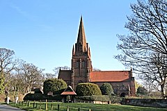
Thurstaston (/ˈθɜːstəstən/ THUR-stə-stən) is a village and former civil parish, in the Wirral district, in Merseyside, England, on the Wirral Peninsula. It is part of the West Kirby and Thurstaston Ward and the parliamentary constituency of Wirral West. The village lies on the A540 road between Heswall and Caldy, although it extends some distance down Station Road to the Wirral Way and the River Dee estuary.
At the time of the 2001 census, the village itself had only 160 inhabitants,[1] although the national census included Caldy and parts of Irby, bringing the total population to 15,548.[3]
- ^ a b "Wirral 2001 Census: Thurstaston". Metropolitan Borough of Wirral. Retrieved 16 July 2007.
- ^ "Coordinate Distance Calculator". boulter.com. Retrieved 6 March 2016.
- ^ "2001 Census: Thurstaston". Office for National Statistics. Retrieved 16 July 2007.
