| Timok Great Timok | |
|---|---|
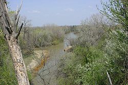
 View of the Timok at Baley, Bulgaria | |
 | |
| Native name | |
| Location | |
| Country | Serbia, Bulgaria |
| City | Serbia: Zaječar, Brusnik Bulgaria: Bregovo, Baley |
| Physical characteristics | |
| Source | Zaječar, Serbia |
| • location | Junction of the Beli Timok and the Crni Timok |
| • coordinates | 43°55′12″N 22°17′52″E / 43.92000°N 22.29778°E |
| Mouth | Danube |
• location | north of Bregovo, Bulgaria / east of Negotin, Serbia |
• coordinates | 44°12′49″N 22°40′13″E / 44.21361°N 22.67028°E |
| Length | 202[1] km (126 mi) |
| Basin size | 4,626[2] km2 (1,786 sq mi) |
| Discharge | |
| • location | mouth |
| • average | 31 m3/s (1,100 cu ft/s) |
| Basin features | |
| Progression | Danube→ Black Sea |
| Tributaries | |
| • left | Crni Timok |
| • right | Beli Timok |
The Timok (Serbian and Bulgarian: Тимок; Romanian: Timoc), sometimes also known as Great Timok (Serbian: Велики Тимок, romanized: Veliki Timok; Romanian: Timocul Mare), is a river in eastern Serbia, a right tributary of the Danube. For the last 15 km of its run it forms a border between eastern Serbia and western Bulgaria.
It is a branchy system of many shorter rivers, many of them having the same name (Timok), only clarified with adjectives. From the farthest source in the system, that of the Svrljiški Timok, until its confluence (as Veliki Timok), the Timok is 202 km long.[1] The area of the river basin is 4,626 km2 (1,786 sq mi).[2] Its average discharge at the mouth is 31 m3/s (1,100 cu ft/s).[3] The Timok Valley is known for the most important Vlach population in Eastern Serbia.
Its name stems from antiquity, in Latin it was known as Timacus and in Ancient Greek Timachos", Τίμαχος.[4]
This in turn comes from Proto-Indo-European *tm̥Hes-, zero-grade of *témHes-, *témHos- (“darkness”), an s-stem from the root *temH- (“dark”), also present in the names of the Thames and Tamiš/Temes/Timiș, possibly with extension "-q" for water (present in Latin "aqua").
- ^ a b Statistical Yearbook of the Republic of Serbia 2017 (PDF) (in Serbian and English). Belgrade: Statistical Office of the Republic of Serbia. October 2017. p. 16. ISSN 0354-4206. Retrieved 30 May 2018.
- ^ a b Velika Morava River Basin, ICPDR, November 2009, p. 2
- ^ "Danube River Basin District, Part A - Roof Report" (PDF). ICPDR. April 2004. p. 12.
- ^ The Cambridge Ancient History Vol. 10, John Boardman, p 579, 1996, ISBN 978-0-521-85073-5