Tinos
Περιφερειακή ενότητα / Δήμος Τήνου | |
|---|---|
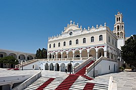
 Panagia Evangelistria, landmark of the island | |
| Coordinates: 37°37′N 25°08′E / 37.617°N 25.133°E | |
| Country | Greece |
| Administrative region | South Aegean |
| Seat | Tinos (town) |
| Area | |
| • Municipality | 194.5 km2 (75.1 sq mi) |
| Population (2021)[1] | |
| • Municipality | 8,934 |
| • Density | 46/km2 (120/sq mi) |
| Time zone | UTC+2 (EET) |
| • Summer (DST) | UTC+3 (EEST) |
| Postal code | 842 xx |
| Area code(s) | 22830 |
| Vehicle registration | EM |
| Website | www |
Tinos (Greek: Τήνος [ˈtinos]) is a Greek island situated in the Aegean Sea. It is part of the Cyclades archipelago. The closest islands are Andros, Delos, and Mykonos. It has a land area of 194.464 square kilometres (75.083 sq mi)[2] and a 2021 census population of 8,934 inhabitants.[3]
Tinos is famous amongst Greeks for the Church of Panagia Evangelistria, its 80 or so windmills,[4] about 1,000 artistic dovecotes, 50 active villages and its Venetian fortifications at the mountain, Exomvourgo. On Tinos, both Greek Orthodox and Catholic populations co-exist, and the island is also well known for its sculptors and painters, such as Nikolaos Gysis, Yannoulis Chalepas and Nikiforos Lytras.
The island is located near the geographical center of the Cyclades island complex, and because of the Panagia Evangelistria church, with its reputedly miraculous icon of Virgin Mary that it holds, Tinos is also the center of a yearly pilgrimage that takes place on the date of the Dormition of the Virgin Mary (15 August, Dekapentavgoustos in Greek).[5] Many pilgrims make their way the 800 metres (2,600 feet) from the ferry wharf to the church on their hands and knees as sign of devotion.
- ^ "Αποτελέσματα Απογραφής Πληθυσμού - Κατοικιών 2021, Μόνιμος Πληθυσμός κατά οικισμό" [Results of the 2021 Population - Housing Census, Permanent population by settlement] (in Greek). Hellenic Statistical Authority. 29 March 2024.
- ^ "Population & housing census 2001 (incl. area and average elevation)" (PDF) (in Greek). National Statistical Service of Greece.
- ^ "Αποτελέσματα Μόνιμου Πληθυσμού κατά δημοτική κοινότητα" (in Greek). Hellenic Statistical Authority. 21 April 2023.
- ^ "Art & Tradition:Windmills". Municipality of Tinos. www.tinos.gr. Archived from the original on 2008-01-05. Retrieved 2007-12-21.
- ^ See, e.g., Theodore Bent, The Cyclades, or Life Among the Insular Greeks. London, 1885, p. 231ff.

