| Titsey | |
|---|---|
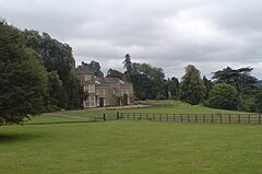
 Titsey Place is the surviving manor of Titsey but a stately home that is open for visitors and is charitably run | |
Location within Surrey | |
| Area | 10.99 km2 (4.24 sq mi) |
| Population | 272 (Civil Parish 2011)[1] |
| • Density | 25/km2 (65/sq mi) |
| OS grid reference | TQ4157 |
| • London | 16 mi (26 km) NNE |
| Civil parish |
|
| District | |
| Shire county | |
| Region | |
| Country | England |
| Sovereign state | United Kingdom |
| Post town | WESTERHAM |
| Postcode district | TN16 |
| Post town | OXTED |
| Postcode district | RH8 |
| Dialling code | 01959 |
| Police | Surrey |
| Fire | Surrey |
| Ambulance | South East Coast |
| UK Parliament | |

Titsey is a rural village and a civil parish on the North Downs almost wholly within the M25 London Orbital Motorway in the Tandridge District of Surrey, England.
In local government it forms the south-western part of the ward Tatsfield and Titsey and in national statistics approximates to output area E00157289. It has no railway stations however one is centred 1.5 miles (2.4 km) south-west, Oxted which also has the administrative centre of the district. Approximately half of it land is owned by a charity running the Titsey Place estate, with the remainder being a mixture of common and privately owned woodland and smallholdings.
- ^ Key Statistics; Quick Statistics: Population Density 2011 United Kingdom census Office for National Statistics Retrieved 21 November 2013
- ^ Margary, Ivan (1948). Roman Ways in the Weald (3 ed.). London: J. M. Dent. p. 133. OCLC 4611036.
