Tlalmanalco | |
|---|---|
Municipality | |
 | |
 | |
| Coordinates: 19°12′16″N 98°48′09″W / 19.20444°N 98.80250°W | |
| Country | |
| State | State of Mexico |
| Municipal Seat | Tlalmanalco de Velázquez |
| Town Founded | 1336 |
| Municipality Created | 1821 |
| Government | |
| • Municipal President | Rubén Reyes Cardoso 2013-2015 |
| Elevation (of seat) | 2,400 m (7,900 ft) |
| Population (2010) Municipality | |
| • Municipality | 46,130 |
| • Seat | 14,664 |
| Time zone | UTC-6 (CST) |
| Postal code (of seat) | 56700 |
| Area code | 597 |
| Website | (in Spanish) / www.tlalmanalco.com/ |
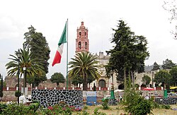
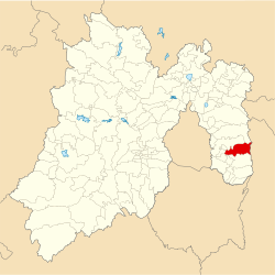
Tlalmanalco is a municipality located in the far south-eastern part of the State of Mexico. The municipal seat and second largest town in the municipality is the town of Tlalmanalco de Velázquez The name is from the Nahuatl language, meaning “flat area.” The municipality's seal shows flat land, with a pyramid on it, representing its pre-Hispanic history, surrounded by small mountains, which is how the area was represented in Aztec codices. The municipality is bordered by the municipalities of Chalco, Ixtapaluca, Cocotitlan, Temamatla, Tenango del Aire, Ayapango and Amecameca. It also shares a border with the neighboring state of Puebla. Much of the municipality borders the Iztaccihuatl-Popocatepetl National Park. For this reason, Iztaccihuatl volcano dominates the landscape.[1] The town has been designated as a “Pueblo con Encanto” (Town with Charm) by the government of the State of Mexico.[2]
- ^ "Enciclopedia de los Municipios de Mexico – Estado de Mexico – Tlalmanalco" (in Spanish). Archived from the original on May 28, 2007. Retrieved 2009-05-06.
- ^ "Blog del Estado de Mexico - Temas-Turismo". Archived from the original on 2009-01-31. Retrieved 2009-05-05.
