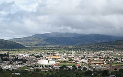
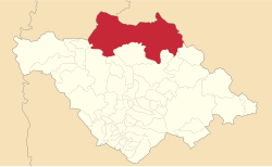
Tlaxco | |
|---|---|
 The town and municipal seat of Tlaxco | |
 Location in Tlaxcala | |
| Coordinates: 19°36′50″N 98°07′07″W / 19.61389°N 98.11861°W[1] | |
| Country | |
| State | |
| Established | 29 August 1945 |
| Seat | Tlaxco |
| Government | |
| • Mayor | Armando Flores López |
| Area | |
| • Total | 575 km2 (222 sq mi) |
| Elevation [1] (of seat) | 2,553 m (8,376 ft) |
| Highest elevation [3] (Cerro Peñas Coloradas) | 3,360 m (11,020 ft) |
| Population (2010 Census)[4] | |
| • Total | 39,939 |
| • Estimate (2015 Intercensal Survey)[5] | 42,536 |
| • Density | 69/km2 (180/sq mi) |
| • Seat | 14,806 |
| Time zone | UTC-6 (Central) |
| Postal code of seat | 90250 |
| Area code | 241 |
| Website | Official website |
Tlaxco (Nahuatl: "place of the ball game"[6]) is a town and its surrounding municipality in the Mexican state of Tlaxcala.
- ^ a b c "Sistema Nacional de Información Municipal" (in Spanish). SEGOB. 2010. Retrieved 17 November 2017.
- ^ "H. Ayuntamiento de Tlaxco 2017-2021". Government of Tlaxco. Retrieved 17 November 2017.
- ^ "Cuaderno Estadística Municipal, Edicíon 1999: Tlaxco, Estado de Tlaxcala" (PDF) (in Spanish). INEGI. 2000. p. 4. Retrieved 17 November 2017.
- ^ "Tlaxco: Datos generales". Cédulas de información municipal (in Spanish). SEDESOL. 2013. Retrieved 17 November 2017.
- ^ Panorama sociodemográfico de Tlaxcala 2015 (PDF). INEGI. 2016. p. 116. ISBN 978-607-739-870-7. Retrieved 17 November 2017.
- ^ "Tlaxco". Enciclopedia de los Municipios y Delegaciones de México (in Spanish). INAFED. Retrieved 17 November 2017.


