| Tockholes | |
|---|---|
 Tockholes village | |
Location within Lancashire | |
| Population | 478 (2011) |
| OS grid reference | SD665235 |
| Civil parish |
|
| Unitary authority | |
| Ceremonial county | |
| Region | |
| Country | England |
| Sovereign state | United Kingdom |
| Post town | DARWEN |
| Postcode district | BB3 |
| Dialling code | 01254 |
| Police | Lancashire |
| Fire | Lancashire |
| Ambulance | North West |
| UK Parliament | |
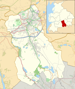
Tockholes is a village and civil parish which forms part of the Blackburn with Darwen unitary authority in the English county of Lancashire,[1] England. Tockholes consists of the village of Tockholes itself and the hamlet of Ryal Fold, and has a population of 454,[2] increasing to 478 at the 2011 Census.[3] It lies on the West Pennine Moors and is surrounded by the towns of Blackburn to the north and Darwen to the east and by the villages of Belmont to the south and Withnell to the west. Darwen Tower is a prominent local landmark that lies to the east of Tockholes and the Roddlesworth Reservoirs and Tockholes forest plantation lie to the south with the M65 passing to the north. There are two churches: Tockholes United Reformed Church and Saint Stephen's Church.
- ^ "North Turton with Tockholes : Statistics and census information : Council and democracy : Blackburn with Darwen Borough Council". Archived from the original on 19 October 2012. Retrieved 24 October 2021.
- ^ Office for National Statistics : Census 2001 : Parish Headcounts : Blackburn with Darwen Archived 12 June 2011 at the Wayback Machine Retrieved 4 February 2010
- ^ UK Census (2011). "Local Area Report – Tockholes Parish (1170211128)". Nomis. Office for National Statistics. Retrieved 6 March 2018.

