 | |
 | |
| Geography | |
|---|---|
| Coordinates | 0°23′30″S 121°57′28″E / 0.39167°S 121.95778°E |
| Area | 237 km2 (92 sq mi)[a] |
| Administration | |
| Province | Central Sulawesi |
| Regency | Tojo Una-Una |
| Demographics | |
| Population | 10,889 (2021)[1] |
| Pop. density | 43.3/km2 (112.1/sq mi) |
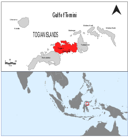
Togean (sometimes spelled Togian) is an Indonesian island in the Gulf of Tomini, part of the Togean Archipelago. It is administratively part of the Tojo Una-Una Regency of Central Sulawesi, consisting largely of the Togean District with the Tanjung Pude village, part of the Una Una District, sitting on the western part of the island.
The island, having a population of just over ten thousand, is separated by a small channel with the slightly bigger Batudaka Island, making it the second largest island in the archipelago. It lies within the Togean Islands National Park, which holds the largest amount of preserved coral reefs by area in the country.
Cite error: There are <ref group=lower-alpha> tags or {{efn}} templates on this page, but the references will not show without a {{reflist|group=lower-alpha}} template or {{notelist}} template (see the help page).
- ^ Badan Pusat Statistik, Jakarta, 2022.