Native name: Kepulauan Togean | |
|---|---|
 | |
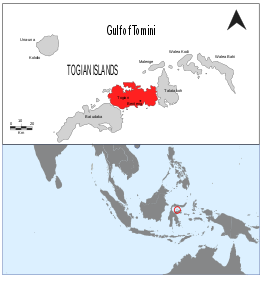
 Map showing the Togian Islands highlighted in red. | |
| Geography | |
| Location | South-east Asia |
| Coordinates | 0°23′30″S 121°57′28″E / 0.39167°S 121.95778°E |
| Total islands | 56 |
| Major islands | Batudaka, Talatako, Togian |
| Administration | |
| Province | Central Sulawesi |
| Demographics | |
| Ethnic groups | Bajau |
| Additional information | |
| Time zone | |


The Togian (or Togean) Islands are an archipelago of 56 islands and many offshore islets, situated in the Gulf of Tomini, off the coast of Central Sulawesi, in Indonesia. The largest islands are Batudaka, Togean, Talatako, Una-Una, Walea Bahi, Walea Kodi and Malenge. There are 59 villages on the islands, with one settled by the Bajau people, more commonly known as the sea gypsies.