Tolleston | |
|---|---|
Neighborhood | |
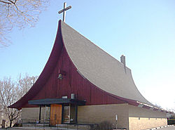
 St. Augustine's Episcopal Church | |
 Location within the city of Gary | |
| Coordinates: 41°35′03″N 87°22′06″W / 41.584246°N 87.368386°W | |
| Country | |
| State | |
| County | Lake County |
| City | Gary |
| First settled | 1857 |
| Incorporated | 1906 |
| Annexed by Gary | 1910 |
| Population (2000)[1] | |
| • Total | 14,289 |
| Time zone | UTC-6 (CST) |
| • Summer (DST) | UTC-5 (CDT) |
| ZIP code | 46404 |
| Area code | 219 |
Tolleston is a neighborhood and former town in west-central Gary, Indiana. It is situated south of Ambridge, west of Midtown, east of Westside and north of Black Oak. Tolleston is the site of two large city parks (MC Bennett Park and Tolleston Park), a historic cemetery, and the oldest church north of the Little Calumet River. The neighborhood's borders are defined by the Norfolk Southern tracks on the north, Grant Street on the east, 25th Avenue on the south, and Clark Road on the west.[1] As of 2000, Tolleston had a population of 14,289, and was 97.5% African-American.[1]
Tolleston is primarily residential, with commercial districts along 11th and 15th Avenues. The housing stock of Tolleston consists chiefly of single-family homes, which as of 2000 had a 92% occupancy rate.[2] The neighborhood was served by the Tolleston Branch of the Gary Public Library which is now closed and is served by the Tolleston Station post office. Distinctive subdivisions within Tolleston include Tarrytown, running for ten blocks north-to-south between Clark Road and Whitcomb Street, and Small Farms at the neighborhood's southern end. Small Farms is the site of some of Gary's most expensive homes.
- ^ a b c City of Gary 2008, p. 154.
- ^ City of Gary 2008, p. 112.