This article may require copy editing for grammar, style, cohesion, tone, or spelling. (April 2024) |
| Tonopah Test Range Airport | |||||||
|---|---|---|---|---|---|---|---|
| Part of Tonopah Test Range | |||||||
| Near Tonopah, Nevada in United States of America | |||||||
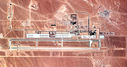
 A satellite image of Tonopah Test Range Airport during 1990, when the 37th Tactical Fighter Wing equipped with the F-117A Nighthawk was stationed there | |||||||
 | |||||||
| Coordinates | 37°47′41″N 116°46′43″W / 37.79472°N 116.77861°W | ||||||
| Type | US Air Force airfield | ||||||
| Site information | |||||||
| Owner | Department of Defense | ||||||
| Operator | US Air Force | ||||||
| Controlled by | Air Combat Command (ACC) | ||||||
| Condition | Operational | ||||||
| Site history | |||||||
| Built | 1957 | ||||||
| In use | 1957 – present | ||||||
| Garrison information | |||||||
| Occupants | 30th Reconnaissance Squadron | ||||||
| Airfield information | |||||||
| Identifiers | IATA: XSD, ICAO: KTNX, FAA LID: TNX, WMO: 724844 | ||||||
| Elevation | 1,691.6 metres (5,550 ft) AMSL | ||||||
| |||||||
| Source: Federal Aviation Administration[1] | |||||||
Tonopah Test Range Airport (IATA: XSD, ICAO: KTNX, FAA LID: TNX),[2][3][4] at the Tonopah Test Range (Senior Trend project site PS-66)[5] is 27 NM (50 km; 31 mi) southeast of Tonopah, Nevada, and 140 mi (230 km) northwest of Las Vegas, Nevada. It is a major airfield with a 12,000 ft × 150 ft (3,658 m × 46 m) runway, instrument approach facilities, and nighttime illumination. The facility has over fifty hangars and an extensive support infrastructure.
- ^ "Airport Diagram – Tonopah Test Range (KTNX)" (PDF). Federal Aviation Administration. 20 June 2019. Retrieved 4 July 2019.
- ^ AirNav: KTNX - Tonopah Test Range
- ^ FlightAware: KTNX - Tonopah Test Range
- ^ Great Circle Mapper: XSD/KTNX - Tonopah, Nevada (Tonopah Test Range)
- ^ F-117 Site History, Stealth Fighter Association webpage, accessed 2011-10-26. Archived January 3, 2011, at the Wayback Machine
