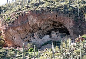
| Tonto National Monument | |
|---|---|
 Lower Cliff Dwelling | |
| Location | Gila County, Arizona, USA |
| Nearest city | Globe, Arizona |
| Coordinates | 33°39′25″N 111°5′40″W / 33.65694°N 111.09444°W |
| Area | 1,120 acres (4.5 km2)[1] |
| Created | December 19, 1907 |
| Visitors | 31,504 (in 2022)[2] |
| Governing body | National Park Service |
| Website | Tonto National Monument |

Tonto National Monument is a National Monument in the Superstition Mountains, in Gila County of central Arizona. The area lies on the northeastern edge of the Sonoran Desert ecoregion, an arid habitat with annual rainfall of about 16 inches (400 mm).[3] The Salt River runs through this area, providing a rare, year-round source of water.
- ^ "Listing of acreage – December 31, 2011" (XLSX). Land Resource Division, National Park Service. Retrieved May 14, 2012. (National Park Service Acreage Reports)
- ^ "NPS Annual Recreation Visits Report". National Park Service. Retrieved July 23, 2023.
- ^ Roosevelt 1 WNW, Arizona – Climate Summary. Western Regional Climate Center.

