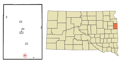
Toronto, South Dakota | |
|---|---|
 Location in Deuel County and the state of South Dakota | |
| Coordinates: 44°34′21″N 96°38′29″W / 44.57250°N 96.64139°W | |
| Country | United States |
| State | South Dakota |
| County | Deuel |
| Founded | 1884[1] |
| Named for | Toronto, Ontario, Canada |
| Area | |
| • Total | 0.31 sq mi (0.80 km2) |
| • Land | 0.31 sq mi (0.80 km2) |
| • Water | 0.00 sq mi (0.00 km2) |
| Elevation | 1,998 ft (609 m) |
| Population | |
| • Total | 196 |
| • Density | 638.44/sq mi (246.35/km2) |
| Time zone | UTC-6 (Central (CST)) |
| • Summer (DST) | UTC-5 (CDT) |
| ZIP code | 57268 |
| Area code | 605 |
| FIPS code | 46-63740[5] |
| GNIS feature ID | 1267602[3] |
| Website | http://www2.torontosd.com/home |
Toronto is a town in Deuel County, South Dakota, United States. The population was 196 at the 2020 census.[6]
Toronto was laid out in 1884, and named after the capital of Ontario, Canada, the native home of a first settler.[7]
- ^ "SD Towns" (PDF). South Dakota State Historical Society. Retrieved 2010-02-16.
- ^ "ArcGIS REST Services Directory". United States Census Bureau. Retrieved October 15, 2022.
- ^ a b U.S. Geological Survey Geographic Names Information System: Toronto, South Dakota
- ^ Cite error: The named reference
USCensusDecennial2020CenPopScriptOnlywas invoked but never defined (see the help page). - ^ "U.S. Census website". United States Census Bureau. Retrieved 2008-01-31.
- ^ "U.S. Census Bureau: Toronto town, South Dakota". www.census.gov. United States Census Bureau. Retrieved 20 February 2022.
- ^ Federal Writers' Project (1940). South Dakota place-names, v.1-3. University of South Dakota. p. 63.