13°15′S 166°37′E / 13.250°S 166.617°E

The Torres Islands are an island chain in the Torba Province of the country of Vanuatu, the country’s northernmost island group. The chain of islands that make up this micro-archipelago straddles the broader cultural boundary between Island Melanesia and several Polynesian outliers located in the neighbouring Solomon Islands. To the island chain’s north is Temotu Province of the Solomon Islands, to its south is Espiritu Santo, and to its southeast are the Banks Islands. To the west, beneath the ocean surface, is the deep Torres Trench, which is the subduction zone between the Australian Plate and Pacific Plate.
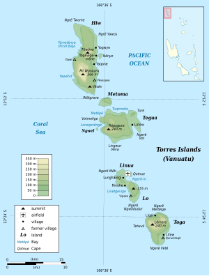
The seven islands in the Torres group, from north to south, are Hiw or Hiu (the largest), Metoma, Tegua, Ngwel (an uninhabited islet), Linua, Lo or Loh, and Toga. The island chain stretches across 42 kilometres (26 miles). The highest point of the chain is only 200 metres (656 feet) above sea level. These islands are less rugged than the other islands of Vanuatu that lie further to the south. Contrary to popular belief, only a few stretches of the Torres Islands' coastlines are graced with white sand beaches; in reality, their shores are mostly made of rocky coral uplift.
As of mid-2004, the Torres Islands had a total population of approximately 950 people, dispersed across at least ten settlements of various sizes, all located on or near coastal areas. The names of these settlements are: Yögevigemëne (or Yögemëne for short), Tinemēvönyö, Yawe and Yakwane (on Hiw), Lotew (on Tegua; sometimes misspelled Lateu), Lungharegi, Telakwlakw and Rinuhe (on Lo), and Likwal and Litew (on Toga). A small airstrip on Linua, opened in 1983, provides the only regular transportation link between the Torres Islands and the rest of Vanuatu. Lungharegi is the administrative centre for the Torres Islands, but its governance role is minimal. It has a community phone and medical clinic, but no bank or police station, and only two sparsely stocked stores.