Tortel | |
|---|---|
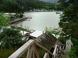
 Wooden walkways in Caleta Tortel | |
| Coordinates: 47°47′49″S 73°31′59″W / 47.79694°S 73.53306°W | |
| Country | Chile |
| Region | Aisén |
| Province | Capitán Prat |
| Seat | Caleta Tortel |
| Government | |
| • Type | Municipality |
| • Alcalde | Bernardo López Sierra (PPD) |
| Area | |
| • Total | 19,930.6 km2 (7,695.2 sq mi) |
| Elevation | 7 m (23 ft) |
| Population (2012 Census)[3] | |
| • Total | 487 |
| • Density | 0.024/km2 (0.063/sq mi) |
| • Urban | 0 |
| • Rural | 507 |
| Sex | |
| • Men | 322 |
| • Women | 185 |
| Time zone | UTC−04:00 (CLT[4]) |
| • Summer (DST) | UTC−03:00 (CLST[5]) |
| Area code | 56 + 67 |
| Website | www.tortel.cl |
Tortel is a Chilean commune located at the outflow of the Baker River and Pascua River to the Pacific Ocean. It lies between the Northern and Southern Patagonian Ice Field in the Capitán Prat Province in the Aysén Region. The commune is administered by the municipality in Caleta Tortel, the principal settlement.
- ^ "Asociación Chilena de Municipalidades" (in Spanish). Retrieved 27 January 2011.
- ^ "Municipality of Tortel" (in Spanish). Retrieved 27 January 2011.
- ^ a b c "National Statistics Institute" (in Spanish). Retrieved 27 January 2010.
- ^ "Chile Time". WorldTimeZones.org. Archived from the original on 11 September 2007. Retrieved 26 September 2010.
- ^ "Chile Summer Time". WorldTimeZones.org. Archived from the original on 11 September 2007. Retrieved 26 September 2010.

