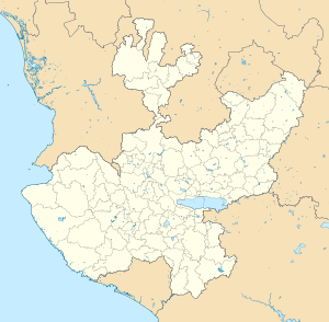
Totatiche | |
|---|---|
 | |
 | |
| Coordinates: 21°56′N 103°27′W / 21.933°N 103.450°W | |
| Country | |
| State | Jalisco |
| Municipality | Totatiche |
| Founded | 1595 |
| Government | |
| • Mayor | Salvador Luna Jara |
| Area | |
| • Municipality | 542.98 km2 (209.65 sq mi) |
| Elevation | 1,751 m (5,745 ft) |
| Population (2005) | |
| • Total | 4,217 |
| • Demonym | Totatichense |
| Time zone | UTC-6 (Central (US Central)) |
| • Summer (DST) | UTC-5 (Central) |
| Postal code | 46-170 |
| Area code | (52) 437 |
| Website | www.totatichejalisco.com |
The municipality and town of Totatiche is located in the northern extreme of the state of Jalisco, Mexico between 21°48’30” and 22°06’00” latitude north and 103°20’00” and 103°34’00” longitude east at a height of 1,751 meters (5,745 ft) above sea level. The municipality is bordered on the north and southeast by the state of Zacatecas. On the northeast, it shares its border with the municipality of Colotlán and on the west it is bordered by the municipalities of Villa Guerrero and Chimaltitán.
The municipality covers an area of 542.98 square kilometers (209.65 sq mi). Its hydrology is defined by the Bolaños river, which demarcates its northern border with Zacatecas and the Cartagenas River which crosses the municipality and flows into the latter. There are five dams in the municipality: Candelaria, Magallanes, Temastián, La Boquilla and Agua Zarca and smaller ones in Romita, San Francisco, and Totolco.


