| Trangie New South Wales | |||||||||
|---|---|---|---|---|---|---|---|---|---|
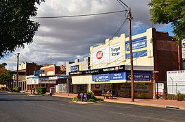
 The main street of Trangie | |||||||||
| Coordinates | 32°02′0″S 147°59′0″E / 32.03333°S 147.98333°E | ||||||||
| Population | 768 (2021 census)[1] | ||||||||
| Postcode(s) | 2823 | ||||||||
| Elevation | 215 m (705 ft) | ||||||||
| Location | |||||||||
| LGA(s) | Narromine Shire | ||||||||
| State electorate(s) | Dubbo | ||||||||
| Federal division(s) | Parkes | ||||||||
| |||||||||
Trangie is a town in the Orana region of New South Wales, Australia. The town is on the Mitchell Highway 485 kilometres (301 mi) north west of the state capital Sydney. It is part of Narromine Shire local government area.[2] At the 2021 census, Trangie had a population of 768.[1] Trangie is on the Main Western railway line, New South Wales
- ^ a b Australian Bureau of Statistics (28 June 2022). "Trangie (L) (Urban Centre/Locality)". 2021 Census QuickStats. Retrieved 22 January 2024.
- ^ ◾Atchison, J F. “The Counties of New South Wales.” The Australian Surveyor, vol. 30, no. 1, Mar. 1980, pp. 39–42.
