Trapper Creek, Alaska | |
|---|---|
 | |
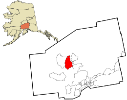
 Location in Matanuska-Susitna Borough and the state of Alaska | |
| Coordinates: 62°18′29″N 150°21′3″W / 62.30806°N 150.35083°W | |
| Country | United States |
| State | Alaska |
| Borough | Matanuska-Susitna |
| Government | |
| • Borough mayor | Edna DeVries |
| • State senator | Mike Shower (R) |
| • State rep. | Kevin McCabe (R) |
| Area | |
| • Total | 327.81 sq mi (849.02 km2) |
| • Land | 320.04 sq mi (828.90 km2) |
| • Water | 7.77 sq mi (20.12 km2) |
| Elevation | 351 ft (107 m) |
| Population | |
| • Total | 499 |
| • Density | 1.56/sq mi (0.60/km2) |
| Time zone | UTC-9 (Alaska (AKST)) |
| • Summer (DST) | UTC-8 (AKDT) |
| ZIP code | 99683 |
| Area code | 907 |
| FIPS code | 02-78680 |
| GNIS feature ID | 1417100 |
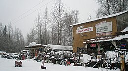
Trapper Creek is a census-designated place (CDP) in Matanuska-Susitna Borough, Alaska, United States. It is part of the Anchorage Metropolitan Area and is known as the southern gateway to Denali State Park. According to the 2020 census the population of Trapper Creek was 499.[2]
- ^ "2021 U.S. Gazetteer Files: Alaska". United States Census Bureau. Retrieved May 4, 2022.
- ^ a b "Trapper Creek CDP, Alaska: 2020 DEC Redistricting Data (PL 94-171)". U.S. Census Bureau. Retrieved May 4, 2022.
