Trent Hills | |
|---|---|
| Municipality of Trent Hills | |
 Hastings as seen across the Trent-Severn Waterway | |
| Coordinates: 44°18′51″N 77°51′05″W / 44.31417°N 77.85139°W[1] | |
| Country | |
| Province | |
| County | Northumberland |
| Established | 2001 |
| Government | |
| • Mayor | Bob Crate |
| • Governing Body | Trent Hills Municipal Council |
| • Federal riding | Northumberland—Peterborough South |
| • Prov. riding | Northumberland—Peterborough South |
| Area | |
| • Land | 511.95 km2 (197.67 sq mi) |
| Population | |
| • Total | 12,900 |
| • Density | 25.2/km2 (65/sq mi) |
| Time zone | UTC-5 (EST) |
| • Summer (DST) | UTC-4 (EDT) |
| Postal code | K0L |
| Area code(s) | 705, 249 |
| Website | www |

5km
3miles
3miles
T R E N T
...
H I L L S
...
H I L L S
T R E N T
...
H I L L S
...
H I L L S
Warkworth
Hastings
Crowe River
Crowe
Bridge
Bridge
Trent River
Trent River
Seymour Lake
Harwood
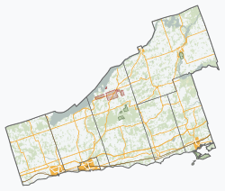
Map of Trent Hills municipality[3]
The Municipality of Trent Hills is a township municipality[1] in Northumberland County in Central Ontario, Canada.[1][3][4][5][6] It is on the Trent River[4][5] and was created in 2001 through the amalgamation of the municipalities of Campbellford/Seymour, Percy Township and Hastings.[3] Thereafter it was known in brief as Campbellford/Seymour, Percy, Hastings.
- ^ a b c "Trent Hills". Geographical Names Data Base. Natural Resources Canada. Retrieved 2018-08-28.
- ^ a b Cite error: The named reference
cp2016was invoked but never defined (see the help page). - ^ a b c Restructured municipalities – Ontario map #5 (Map). Restructuring Maps of Ontario. Ontario Ministry of Municipal Affairs and Housing. 2006. Archived from the original on May 11, 2020. Retrieved March 20, 2018.
- ^ a b "Toporama". Atlas of Canada. Natural Resources Canada. 12 September 2016. Retrieved 2018-08-28.
- ^ a b "Ontario Geonames GIS (on-line map and search)". Ontario Ministry of Natural Resources and Forestry. 2014. Retrieved 2018-08-28.
- ^ Map 6 (PDF) (Map). 1 : 700,000. Official road map of Ontario. Ministry of Transportation of Ontario. 2018-01-01. Retrieved 2018-08-28.


