Tribeca | |
|---|---|
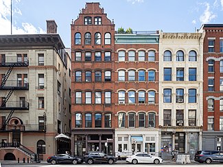
 Hudson Street in Tribeca | |
 Location in New York City | |
| Coordinates: 40°43′05″N 74°00′29″W / 40.718°N 74.008°W | |
| Country | |
| State | |
| City | New York City |
| Borough | Manhattan |
| Community District | Manhattan 1[1] |
| Area | |
| • Total | 2.35 km2 (0.909 sq mi) |
| Population (2010)[2] | |
| • Total | 42,742 |
| • Density | 18,000/km2 (47,000/sq mi) |
| Economics | |
| • Median income | $196,692 |
| ZIP Codes | 10007, 10013 |
| Area codes | 212, 332, 646, and 917 |
Tribeca (/traɪˈbɛkə/ try-BEK-ə), originally written as TriBeCa, is a neighborhood in Lower Manhattan in New York City. Its name is a syllabic abbreviation of "Triangle Below Canal Street".[3] The "triangle" (more accurately a quadrilateral) is bounded by Canal Street, West Street, Broadway, and Chambers Street. By the 2010s, a common marketing tactic was to extend Tribeca's southern boundary to either Vesey or Murray Streets to increase the appeal of property listings.[4]
The neighborhood began as farmland, then was a residential neighborhood in the early 19th century, before becoming a mercantile area centered on produce, dry goods, and textiles, and then transitioning to artists and then actors, models, entrepreneurs, and other celebrities. The neighborhood is home to the Tribeca Festival, which was created in response to the September 11 attacks, to reinvigorate the neighborhood and downtown after the destruction caused by the terrorist attacks.[5]
Tribeca is part of Manhattan Community District 1, and its primary ZIP Codes are 10007 and 10013.[1] It is patrolled by the 1st Precinct of the New York City Police Department.
- ^ a b "NYC Planning | Community Profiles". communityprofiles.planning.nyc.gov. New York City Department of City Planning. Archived from the original on March 20, 2019. Retrieved March 18, 2019.
- ^ a b Cite error: The named reference
PLP5was invoked but never defined (see the help page). - ^ Presson, Chandler. "The Ultimate Guide to NYC's Tribeca", Gotham March 1, 2023. Accessed March 31, 2024. "The name Tribeca is actually a syllabic abbreviation for 'Triangle Below Canal,' referring to the coveted cobblestone streets that make up the neighborhood."
- ^ Hall, Miriam (October 1, 2017). "Blurring the Boundaries Archived August 18, 2019, at the Wayback Machine". The Real Deal. Retrieved February 2, 2019.
- ^ Cite error: The named reference
enc-nycwas invoked but never defined (see the help page).