| Trident Volcano | |
|---|---|
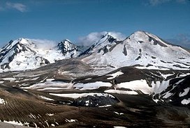
 Multiple peaks of Trident Volcano, from the top of Baked Mountain, Valley of Ten Thousand Smokes. | |
| Highest point | |
| Elevation | 6,115 ft (1,864 m)[1] |
| Coordinates | 58°14′06″N 155°06′13″W / 58.235°N 155.1036111°W[2] |
| Geography | |
 | |
| Location | Katmai National Park and Preserve, Alaska, U.S. |
| Parent range | Aleutian Range |
| Topo map | USGS Mount Katmai A-4 |
| Geology | |
| Mountain type | Stratovolcano |
| Volcanic arc/belt | Aleutian Arc |
| Last eruption | July 1974[3] |
Trident Volcano is an eroded volcanic complex on the Alaska Peninsula in Katmai National Park, Alaska. Up to 23 domes comprise the complex stratovolcano, with the greatest elevation of 6,115 feet (1,864 m). The most recent major activity produced a 3,599-foot (1,097 m) dome in an amphitheater on the southwest flank of the southwest peak. Volcano Novarupta formed on its slopes in the largest volcanic eruption of the 20th century.
According to the United States Geological Survey, the descriptive name, Trident, was given by Robert Fiske Griggs of the National Geographic Society, in 1916, because there were three major peaks.[2] The volcano has been known by several variants of the name. The feature was officially named Mount Trident by the United States Board on Geographic Names in 1928. The board assigned the current name in 1968.[2]
- ^ "Trident Volcano". Bivouac.com. Retrieved 2008-12-26.
- ^ a b c "Trident Volcano". Geographic Names Information System. United States Geological Survey, United States Department of the Interior. Retrieved 2008-12-26.
- ^ "Trident". Alaska Volcano Observatory. Retrieved 2008-12-26.