| Trione-Annadel State Park | |
|---|---|
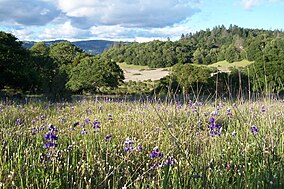
 Lupines in a meadow, Annadel State Park | |
| Location | Sonoma County, California, United States |
| Nearest city | Kenwood, California; Santa Rosa, California |
| Coordinates | 38°25′45″N 122°37′30″W / 38.42917°N 122.62500°W |
| Area | 5,092 acres (2,061 ha) |
| Established | 1971 |
| Governing body | California Department of Parks and Recreation |
Trione-Annadel State Park is a state park of California in the United States. It is situated at the northern edge of Sonoma Valley and is adjacent to Spring Lake Regional Park in Santa Rosa. It offers many recreational activities within its 5,092-acre (2,061 ha) property.
The rock formations of Trione-Annadel have played a central role in its history: its volcanic origins, the Native American use of obsidian, the early 1900s mining of cobblestones, and modern hikers' appreciation of its volcanic rock outcrops.
These lands were occupied by the Wappo and Pomo people in prehistoric times, who would have primarily inhabited the riparian zones and the marsh perimeter. Annadel includes what some biologists consider the best example of undisturbed northern oak woodlands in existence.[1] Visitors can enjoy the park's diverse wildlife and scenery during any time of the year but are perhaps most rewarded from April through June when most wildflowers are in bloom.
The 2017 Nuns fire burned the southern portion of the park.[2] In 2020, the Glass fire burned the northern edge of the park.
- ^ Annadel State Park facts
- ^ Perkins, Jonathan (June 2022). "Map of Nuns Fire burn area".

