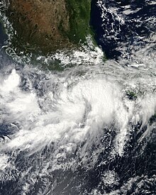
 Tropical Storm Trudy shortly after being named on October 17 | |
| Meteorological history | |
|---|---|
| Formed | October 17, 2014 |
| Dissipated | October 19, 2014 |
| Tropical storm | |
| 1-minute sustained (SSHWS/NWS) | |
| Highest winds | 65 mph (100 km/h) |
| Lowest pressure | 998 mbar (hPa); 29.47 inHg |
| Overall effects | |
| Fatalities | 9 total |
| Damage | >$12.3 million (2014 USD) |
| Areas affected | Southern Mexico |
| IBTrACS | |
Part of the 2014 Pacific hurricane season | |
Tropical Storm Trudy was a short-lived tropical cyclone in October 2014 that caused significant flooding in southern Mexico. The storm originated from an area of low pressure associated with a monsoon trough near Central America in early October. A slow-moving system, the low eventually consolidated into a tropical depression on October 17 near the Mexican coastline. Favorable environmental conditions aided rapid development of Trudy. Within 15 hours of its designation, an eye formed over the storm's center. Trudy ultimately achieved its peak intensity as a strong tropical storm with 65 mph (100 km/h) winds as it made landfall just southeast of Marquelia, Mexico. The region's mountainous terrain quickly weakened Trudy and the cyclone dissipated early on October 19. Though the cyclone dissipated, its remnant energy later contributed to the formation of Tropical Storm Hanna in the Atlantic.
Prior to Trudy's landfall, the Government of Mexico issued multiple watches and warnings for the threatened region. Forecasters highlighted the threat of heavy rains and mudslides. Guerrero experienced the greatest effects from Trudy, with landslides and flooding claiming eight lives in the state. Over 4,000 people were evacuated in the region. A ninth fatality took place in Campeche.