Trostianets
Тростянець | |
|---|---|
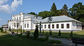
 Manor of the Nadarzhinsky-Golitsyns | |
| Coordinates: 50°28′N 34°57′E / 50.467°N 34.950°E | |
| Country | |
| Oblast | Sumy Oblast |
| Raion | Okhtyrka Raion |
| Hromada | Trostianets urban hromada |
| Founded | 1660 |
| Government | |
| • Mayor | Yuri Bova (Power of the People) |
| Area | |
| • Total | 23.8 km2 (9.2 sq mi) |
| Elevation | 122 m (400 ft) |
| Population (2022) | |
| • Total | 19,544 |
| Time zone | UTC+2 (EET) |
| • Summer (DST) | UTC+3 (EEST) |
| Postal codes | 42600-42615 |
| Area code | +380 5458 |
| Website | Official website |
Trostianets (also Trostyanets; Ukrainian: Тростянець, pronounced [trosʲtʲɐˈnɛt͡sʲ]; Russian: Тростянец) is a city in Okhtyrka Raion of Sumy Oblast of northeastern Ukraine. It was the administrative center of Trostianets Raion until it was abolished on 18 July 2020. The city lies on the Boromlya River, 59 km (37 mi) from Sumy. Landmarks include a neo-Gothic "round courtyard" (1749), the late Baroque church of the Annunciation (1744–50), the 18th-century Galitzine palace, and a "grotto of nymphs" (an 1809 centenary memorial to the Battle of Poltava). The city has a population of 19,544 (2022 estimate).[1]
Many were killed and the city was badly damaged during the 2022 Russian invasion of Ukraine.
- ^ Чисельність наявного населення України на 1 січня 2022 [Number of Present Population of Ukraine, as of January 1, 2022] (PDF) (in Ukrainian and English). Kyiv: State Statistics Service of Ukraine. Archived (PDF) from the original on 4 July 2022.


