Troutville, Virginia | |
|---|---|
 Mill Creek Baptist Church | |
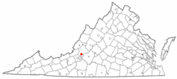
 Location of Troutville, Virginia | |
| Coordinates: 37°24′55″N 79°52′37″W / 37.41528°N 79.87694°W | |
| Country | United States |
| State | Virginia |
| County | Botetourt |
| Area | |
| • Total | 0.69 sq mi (1.79 km2) |
| • Land | 0.69 sq mi (1.79 km2) |
| • Water | 0.00 sq mi (0.00 km2) |
| Elevation | 1,391 ft (424 m) |
| Population (2020) | |
| • Total | 458 |
| • Density | 663.77/sq mi (255.87/km2) |
| Time zone | UTC-5 (Eastern (EST)) |
| • Summer (DST) | UTC-4 (EDT) |
| ZIP code | 24175 |
| Area code | 540 |
| FIPS code | 51-79472[2] |
| GNIS feature ID | 1493720[3] |
| Website | https://townoftroutville-va.gov/ |
Troutville is a town in Botetourt County, Virginia, United States. The population was 458 at the 2020 census. The town is located along the U.S. Route 11 between Cloverdale and Buchanan. It is part of the Roanoke Metropolitan Statistical Area.
- ^ "2019 U.S. Gazetteer Files". United States Census Bureau. Retrieved August 7, 2020.
- ^ "U.S. Census website". United States Census Bureau. Retrieved 2011-05-14.
- ^ "Troutville". Geographic Names Information System. United States Geological Survey, United States Department of the Interior.
