Trpinja
| |
|---|---|
| Municipality of Trpinja Općina Trpinja Општина Трпиња | |
Villages of the Trpinja Municipality | |
 | |
| Coordinates: 45°25′N 18°54′E / 45.417°N 18.900°E | |
| Country | |
| Region | Slavonia (Podunavlje) |
| County | |
| Municipal seat Largest settlement | Trpinja Bobota |
| Government | |
| • Municipal mayor | Miroslav Palić[3] (SDSS[3]) |
| Area | |
| • Municipality | 122.8 km2 (47.4 sq mi) |
| • Urban | 30.0 km2 (11.6 sq mi) |
| Elevation | 86 m (282 ft) |
| Population (2021)[5] | |
| • Municipality | 4,167 |
| • Density | 34/km2 (88/sq mi) |
| • Urban | 1,130 |
| • Urban density | 38/km2 (98/sq mi) |
| Demonym(s) | Trpinjanin (♂) Trpinjanka (♀) (per grammatical gender) |
| Time zone | UTC+1 (CET) |
| • Summer (DST) | UTC+2 (CEST) |
| Postal code | 32224 Trpinja |
| Area code | 32 |
| Vehicle registration | VU |
| Official languages | Croatian, Serbian[2] |
| Municipality established | April 13, 1997[6] |
| Website | opcinatrpinja |
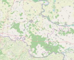
Trpinja (Serbian Cyrillic: Трпиња, Hungarian: Terpenye) is a village and an eponymous municipality in the Vukovar-Syrmia County in eastern Croatia. The village is located on the D55 road between Osijek and Vukovar. Landscape of the Trpinja Municipality is marked by the Pannonian Basin plains and agricultural fields of maize, wheat, common sunflower and sugar beet.
The Municipality of Trpinja was established in 1997 by the UNTAES administration as one of new predominantly Serb municipalities in order to ensure access to local self-government to Serb community in the region after the end of the Croatian War of Independence. The municipality is northernmost one in the Vukovar-Syrmia Country and there are in total 7 villages within municipal boundaries. At the time of 2011 census the municipality had a population of 5,572 and the village of Trpinja itself 1,537.
- ^ Cite error: The named reference
Statutwas invoked but never defined (see the help page). - ^ a b Government of Croatia (October 2013). "Peto izvješće Republike Hrvatske o primjeni Europske povelje o regionalnim ili manjinskim jezicima" (PDF) (in Croatian). Council of Europe. p. 36. Retrieved 30 November 2016.
- ^ a b "Informacija o rezultatima izbora članova predstavničkih tijela jedinica lokalne i područne (regionalne) samouprave" (PDF). Archived from the original (PDF) on 2012-08-13. Retrieved 2013-03-10.
- ^ Register of spatial units of the State Geodetic Administration of the Republic of Croatia. Wikidata Q119585703.
- ^ "Population by Age and Sex, by Settlements" (xlsx). Census of Population, Households and Dwellings in 2021. Zagreb: Croatian Bureau of Statistics. 2022.
- ^ "O općini". Retrieved 2015-03-15.


