Truro, Massachusetts | |
|---|---|
 Truro Town Hall | |
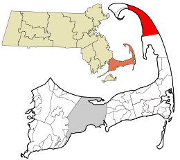
 Location in Barnstable County and the Commonwealth of Massachusetts. | |
| Coordinates: 41°59′36″N 70°03′01″W / 41.99333°N 70.05028°W | |
| Country | United States |
| State | Massachusetts |
| County | Barnstable |
| Settled | 1700 |
| Incorporated | 1709 |
| Government | |
| • Type | Open town meeting |
| Area | |
| • Total | 26.3 sq mi (68.2 km2) |
| • Land | 21.1 sq mi (54.5 km2) |
| • Water | 5.3 sq mi (13.6 km2) |
| Elevation | 25 ft (8 m) |
| Population (2020) | |
| • Total | 2,454 |
| • Density | 116.3/sq mi (45.0/km2) |
| Time zone | UTC-5 (Eastern) |
| • Summer (DST) | UTC-4 (Eastern) |
| ZIP code | 02666 |
| Area code | 508 |
| FIPS code | 25-70605 |
| GNIS feature ID | 0618260 |
| Website | truro-ma.gov |
Truro /ˈtrɜːroʊ/ is a town in Barnstable County, Massachusetts, United States, comprising two villages: Truro and North Truro. Located slightly more than 100 miles (160 km) by road from Boston, it is a summer vacation community just south of the northern tip of Cape Cod, in an area known as the "Outer Cape".[1] English colonists named it after Truro in Cornwall, United Kingdom.
The historic Wampanoag Native American people called the area Pamet or Payomet. Their language was part of the large Algonquian family. This name was adopted for the Pamet River and the harbor area around the town center known as the Pamet Roads.[2] The population of Truro was 2,454 at the 2020 census.[3]
Over half of the land area of the town is part of the Cape Cod National Seashore, established in 1961 by President John F. Kennedy, and administered by the U.S. National Park Service.
- ^ Sheedy, Jack and Coogan, Jim. Cape Cod Voyage: A Journey Through Cape Cod's History and Lore[permanent dead link], East Dennis, Massachusetts: Harvest Home Books, 2001, p. 19 The "lower" Cape is the northernmost part of Cape Cod, while the "upper" Cape is to the south. These directional terms were determined in seafaring days by the prevailing westerly winds, which were of paramount importance during the time when sailed boats were a primary form of travel. A boat sailing south-to-north on Cape Cod Bay would have the wind at its back, and was thus traveling "down", while the opposite was true of a boat sailing north-to-south.
- ^ "Roads", Dictionary.com. "Roads" in the nautical sense of "a partly sheltered area of water near a shore in which vessels may ride at anchor."
- ^ "Census - Geography Profile: Truro town, Barnstable County, Massachusetts". Retrieved October 6, 2021.

