| Truro South Australia | |||||||||||||||
|---|---|---|---|---|---|---|---|---|---|---|---|---|---|---|---|
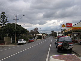
 The Sturt Highway, the main street of Truro, (looking west towards the Barossa Valley and Adelaide) | |||||||||||||||
| Coordinates | 34°24′0″S 139°07′0″E / 34.40000°S 139.11667°E | ||||||||||||||
| Population | 523 (2021 census)[1] | ||||||||||||||
| Established | 1847 (town) 16 March 2000 (locality)[2] | ||||||||||||||
| Postcode(s) | 5356 | ||||||||||||||
| Location | |||||||||||||||
| LGA(s) | |||||||||||||||
| State electorate(s) | Stuart | ||||||||||||||
| Federal division(s) | Barker | ||||||||||||||
| |||||||||||||||
Truro (postcode 5356, altitude 311m) is a town in South Australia, 80 km northeast of Adelaide. It is situated in an agricultural and pastoral district on the Sturt Highway, east of the Barossa Valley, where the highway crosses somewhat lofty and rugged parts of the Mount Lofty Ranges. At the 2021 census, Truro had a population of 523.[1]
Truro is in the Mid Murray Council local government area, the South Australian House of Assembly electoral district of Schubert and the Australian House of Representatives Division of Barker.
- ^ a b Australian Bureau of Statistics (28 June 2022). "Truro". 2021 Census QuickStats. Retrieved 23 July 2022.
- ^ "GEOGRAPHICAL NAMES ACT 1991, Notice to Assign Names and Boundaries to Places (within the District Council of Kapunda and Light )" (PDF). The South Australian Government Gazette. South Australian Government. 16 March 2000. p. 1433. Retrieved 6 March 2018.
