| Tucson Mountains | |
|---|---|
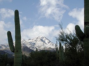
 Wasson Peak is the highest point in the Tucson Mountains. Unlike what this picture shows, snow is extremely rare in these mountains, especially in the amount seen here. | |
| Highest point | |
| Peak | Wasson Peak[1] |
| Elevation | 4,687 ft (1,429 m) |
| Coordinates | 32°16.4′N 111°8.8′W / 32.2733°N 111.1467°W |
| Geography | |
Tucson Mountains in Arizona | |
| Country | United States |
| State | Arizona |
| Region | Sonoran Desert |
| County | Pima |
| City | Tucson, Arizona |
| Range coordinates | 32°13′30″N 111°7′0″W / 32.22500°N 111.11667°W |
| Topo map(s) | USGS Cat Mountain, Arizona, Jaynes, Arizona, Avra, Arizona, Brown Mountain, Arizona |
The Tucson Mountains (O'odham: Cuk Doʼag) are a minor mountain range west of Tucson, Arizona, United States. The Tucson Mountains, including Wasson Peak, are one of four notable mountain ranges surrounding the Tucson Basin. The Santa Catalina Mountains lie to the northeast, the Rincon Mountains are to the east of Tucson, and the Santa Rita Mountains lie to the south. Additionally, the Sierrita Mountains lie due south, the Roskruge Mountains lie to the west across Avra Valley, the Silver Bell Mountains lie to the northwest, and the Tortolita Mountains lie to the north across the Santa Cruz Valley.[2]
