Tufanbeyli | |
|---|---|
District and municipality | |
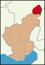
 Map showing Tufanbeyli District in Adana Province | |
| Coordinates: 38°15′53″N 36°13′21″E / 38.26472°N 36.22250°E | |
| Country | Turkey |
| Province | Adana |
| Government | |
| • Mayor | Ahmet Aktürk (CHP) |
| Area | 851 km2 (329 sq mi) |
| Elevation | 1,450 m (4,760 ft) |
| Population (2022)[1] | 16,400 |
| • Density | 19/km2 (50/sq mi) |
| Time zone | UTC+3 (TRT) |
| Postal code | 01640 |
| Area code | 0322 |
| Website | www |
Tufanbeyli is municipality and district of Adana Province, Turkey.[2] Its area is 851 km2,[3] and its population is 16,400 (2022).[1] It is 196 km north-east of the city of Adana, on an uneven, sloping plateau high in the Tahtalı range of the Taurus Mountains. It has been bounded economically to Kayseri, 178 km far. Its neighbors are Sarız from North, Göksun from east, Saimbeyli from south, Develi from south-west and Tomarza from west.[citation needed]
Tufanbeyli is reached by crossing one of three high mountain passes. It's a struggle to reach but the views are incredible. The river Göksu, a tributary of the Seyhan runs across the plateau. The climate is hot dry summers and cold winters. The mountains are forested but these are steadily being consumed by the local people.[citation needed]
- ^ a b "Address-based population registration system (ADNKS) results dated 31 December 2022, Favorite Reports" (XLS). TÜİK. Retrieved 12 July 2023.
- ^ Büyükşehir İlçe Belediyesi, Turkey Civil Administration Departments Inventory. Retrieved 12 July 2023.
- ^ "İl ve İlçe Yüz ölçümleri". General Directorate of Mapping. Retrieved 12 July 2023.
