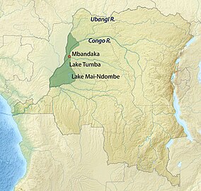
| Tumba-Ngiri-Maindombe | |
|---|---|
 | |
 Location in the DRC | |
| Nearest city | Mbandaka |
| Coordinates | 0°40′55″S 18°00′01″E / 0.681823°S 18.000412°E |
| Area | 65,696 square kilometres (25,365 sq mi) |
| Established | 2008 |
| Official name | Ngiri-Tumba-Maindombe |
| Designated | 24 July 2008 |
| Reference no. | 1784[1] |
Tumba-Ngiri-Maindombe is the largest Wetland of International Importance in the world as recognized by the Ramsar Convention.[fn 1] The site covers an area of 65,696 square kilometres (25,365 sq mi) in the region around Lake Tumba in the western Congo Basin in the Democratic Republic of the Congo (DRC). This is more than twice the size of Belgium or Maryland.[3][4]
The vast area of forest and permanent or seasonal lakes and marshlands has great environmental and economic value. However, a rapidly growing population combined with weak and corrupt governance may be contributing to irreversible destruction.[5]
- ^ "Ngiri-Tumba-Maindombe". Ramsar Sites Information Service. Retrieved 25 April 2018.
- ^ Mat McDermott (July 24, 2008). "Wetland 'Carbon Bomb' Has One of Its Wires Cut: Democratic Republic of Congo Creates World's Largest Protected Wetland". TreeHugger. Retrieved 2012-01-28.
- ^ Cite error: The named reference
ENS20080724was invoked but never defined (see the help page). - ^ Cite error: The named reference
WWF20080816was invoked but never defined (see the help page). - ^ Cite error: The named reference
Kantuwas invoked but never defined (see the help page).
Cite error: There are <ref group=fn> tags on this page, but the references will not show without a {{reflist|group=fn}} template (see the help page).