Tumwater, Washington | |
|---|---|
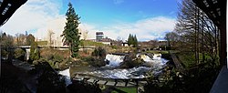
 Panoramic view of the upper falls and the former Olympia Brewery, 2011 | |
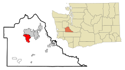
 Location of Tumwater, Washington | |
| Coordinates: 47°0′28″N 122°54′40″W / 47.00778°N 122.91111°W | |
| Country | United States |
| State | Washington |
| County | Thurston |
| Incorporated | November 25, 1869[1] |
| Government | |
| • Type | Mayor–council |
| • Mayor | Debbie Sullivan[2] |
| Area | |
| • Total | 17.76 sq mi (46.00 km2) |
| • Land | 17.50 sq mi (45.32 km2) |
| • Water | 0.26 sq mi (0.67 km2) |
| Elevation | 174 ft (53 m) |
| Population | |
| • Total | 25,350 |
| • Estimate (2021)[5] | 25,844 |
| • Density | 1,372.80/sq mi (530.04/km2) |
| Time zone | UTC-8 (PST) |
| • Summer (DST) | UTC-7 (PDT) |
| ZIP codes | 98501, 98511, 98512 |
| Area code | 360 |
| FIPS code | 53-72905 |
| GNIS feature ID | 1512742[6] |
| Website | ci.tumwater.wa.us |

Tumwater is a city in Thurston County, Washington, United States. The population was 25,350 at the 2020 census.[4] The city is situated near where the Deschutes River enters Budd Inlet, the southernmost point of Puget Sound; it also borders the state capital of Olympia to the north. Tumwater is the oldest permanent Anglo-American settlement on Puget Sound.[7]
- ^ "Tumwater History". Archived from the original on July 30, 2009. Retrieved May 26, 2009.
- ^ "Meet the Tumwater Mayor and City Council". City of Tumwater. Retrieved April 6, 2024.
- ^ "2019 U.S. Gazetteer Files". United States Census Bureau. Retrieved August 7, 2020.
- ^ a b "Explore Census Data". United States Census Bureau. Retrieved May 15, 2022.
- ^ Cite error: The named reference
USCensusEst2021was invoked but never defined (see the help page). - ^ "US Board on Geographic Names". United States Geological Survey. October 25, 2007. Retrieved January 31, 2008.
- ^ "History," Archived September 2, 2021, at the Wayback Machine City of official website. Retrieved January 28, 2020.