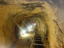
 Inside one of the most spacious parts of the Eupalinian aqueduct | |
| Overview | |
|---|---|
| Location | Samos Island, Greece |
| Coordinates | 37°41′38″N 26°55′48″E / 37.694°N 26.930°E |
| Status | Open |
| Operation | |
| Opened | circa 6th century BCE |
| Technical | |
| Design engineer | Eupalinos |
| Length | 1036 m |
| Part of | Pythagoreion and Heraion of Samos |
| Criteria | Cultural: (ii)(iii) |
| Reference | 595-001 |
| Inscription | 1992 (16th Session) |
| Area | 285.9 ha (706 acres) |
| Buffer zone | 402.25 ha (994.0 acres) |
The Tunnel of Eupalinos or Eupalinian aqueduct (Greek: Ευπαλίνιον όρυγμα, romanized: Efpalinion orygma) is a tunnel of 1,036 m (3,399 ft) length running through Mount Kastro in Samos, Greece, built in the 6th century BC to serve as an aqueduct.[1] The tunnel is the second known tunnel in history which was excavated from both ends (Ancient Greek: ἀμφίστομον, romanized: amphistomon, "having two openings"), and the first with a geometry-based approach in doing so.[2] Today it is a popular tourist attraction. The tunnel is inscribed on the UNESCO World Heritage List along with the nearby Pythagoreion and Heraion of Samos, and it was designated as an International Historic Civil Engineering Landmark in 2017.[3][4]
- ^ Cite error: The named reference
AqueductEvolutionwas invoked but never defined (see the help page). - ^ The oldest known tunnel at which two teams advanced simultaneously is the Siloam tunnel in Jerusalem, completed around 700 BC. It has been posited that it was dug by maintaining depths close enough to the surface of the solid karst that the diggers could hear loud banging from the surface guiding the two teams towards one another. Frumkin, Amos; Shimron, Aryeh (2006). "Tunnel engineering in the Iron Age: Geoarchaeology of the Siloam Tunnel, Jerusalem". Journal of Archaeological Science. 33 (2): 227–237. Bibcode:2006JArSc..33..227F. doi:10.1016/j.jas.2005.07.018.
- ^ "Ανακήρυξη του Ευπαλίνειου Όρυγματος ως Ιστορικού Τοπόσημου Τεχνολογίας Πολιτικού Μηχανικού" [Designation of Tunnel of Eupalinos as a Historical Civil Engineering Landmark]. National Technical University of Athens School of Civil Engineering (in Greek). 29 October 2017. Retrieved 20 August 2022.
- ^ "Pythagoreion and Heraion of Samos". UNESCO World Heritage Convention. United Nations Educational Scientific and Cultural Organization. Retrieved 25 November 2022.