You can help expand this article with text translated from the corresponding article in French. (July 2014) Click [show] for important translation instructions.
|
Turckheim | |
|---|---|
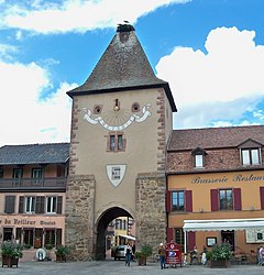
 Entrance to Turckheim through the Porte de France | |
| Coordinates: 48°05′14″N 7°16′52″E / 48.0872°N 7.2811°E | |
| Country | France |
| Region | Grand Est |
| Department | Haut-Rhin |
| Arrondissement | Colmar-Ribeauvillé |
| Canton | Wintzenheim |
| Intercommunality | Colmar Agglomération |
| Government | |
| • Mayor (2020–2026) | Benoît Schlussel[1] |
| Area 1 | 16.46 km2 (6.36 sq mi) |
| Population (2021)[2] | 3,928 |
| • Density | 240/km2 (620/sq mi) |
| Time zone | UTC+01:00 (CET) |
| • Summer (DST) | UTC+02:00 (CEST) |
| INSEE/Postal code | 68338 /68230 |
| Elevation | 219–840 m (719–2,756 ft) (avg. 240 m or 790 ft) |
| 1 French Land Register data, which excludes lakes, ponds, glaciers > 1 km2 (0.386 sq mi or 247 acres) and river estuaries. | |
Imperial City of Turckheim | |||||||||
|---|---|---|---|---|---|---|---|---|---|
| 1312–1648 | |||||||||
| Status | Free Imperial City of the Holy Roman Empire | ||||||||
| Capital | Turckheim | ||||||||
| Government | Republic | ||||||||
| Historical era | Middle Ages | ||||||||
• Gained Imp. immediacy | 1312 | ||||||||
| 1354 | |||||||||
| 24 October 1648 | |||||||||
26 January 1679 | |||||||||
| |||||||||
| Today part of | France | ||||||||
Turckheim (French pronunciation: [tyʁkaim] ; Alsatian: Tercka; German: Türkheim) is a commune in the Haut-Rhin department in Grand Est in north-eastern France. It lies west of Colmar, on the eastern slopes of the Vosges mountains.
- ^ "Répertoire national des élus: les maires" (in French). data.gouv.fr, Plateforme ouverte des données publiques françaises. 13 September 2022.
- ^ "Populations légales 2021" (in French). The National Institute of Statistics and Economic Studies. 28 December 2023.


