 Tutuila and Aunu'u from Earth orbit | |
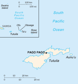
 Map of Tutuila Island in American Samoa | |
| Geography | |
|---|---|
| Location | Pacific Ocean |
| Coordinates | 14°17′42″S 170°42′00″W / 14.295°S 170.70°W |
| Archipelago | Samoan Islands |
| Area | 142.3 km2 (54.9 sq mi) |
| Highest elevation | 653 m (2142 ft) |
| Highest point | Matafao Peak |
| Administration | |
United States | |
| Territory | American Samoa |
| Largest settlement | Pago Pago (pop. 11,500) |
| Demographics | |
| Population | 55,876 (2000) |
| Pop. density | 394.89/km2 (1022.76/sq mi) |

Tutuila is the largest and most populous island of American Samoa and is part of the archipelago of the Samoan Islands. It is the third largest island in the Samoan Islands chain of the Central Pacific. It is located roughly 4,000 kilometers (2,500 mi) northeast of Brisbane, Australia and lies over 1,200 kilometers (750 mi) to the northeast of Fiji. It contains a large, natural harbor, Pago Pago Harbor, where Pago Pago, the capital of American Samoa, is situated. Pago Pago International Airport is also located on Tutuila. The island's land expanse is about 68% of the total land area of American Samoa. With 56,000 inhabitants, it is also home to 95% of the population of American Samoa.[1] The island has six terrestrial and three marine ecosystems.[2]
Tutuila has mountainous regions, the highest point of which is 653 meters (2,142 feet). The island is attractive to tourists because of its beaches, coral reefs, and World War II relics, as well as its suitability for sporting activities such as scuba diving, snorkeling, and hiking.[1]
- ^ a b Stanley, David (2004). Moon Handbooks South Pacific. David Stanley. p. 475. ISBN 978-1-56691-411-6. Retrieved December 18, 2010.
Report on Hurricane Val in American Samoa.
- ^ "Islands of American Samoa (United States)". Tutuila (391). UN System-Wide Earthwatch Web Site. Retrieved November 24, 2010.