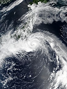
|name=. Remove this parameter; the article title is used as the name by default. Jongdari shortly after peak intensity, while approaching Japan on July 28 | |
| Meteorological history | |
|---|---|
| Formed | July 23, 2018 |
| Dissipated | August 4, 2018 |
| Typhoon | |
| 10-minute sustained (JMA) | |
| Highest winds | 140 km/h (85 mph) |
| Lowest pressure | 960 hPa (mbar); 28.35 inHg |
| Category 2-equivalent tropical cyclone | |
| 1-minute sustained (SSHWS/JTWC) | |
| Highest winds | 165 km/h (105 mph) |
| Lowest pressure | 950 hPa (mbar); 28.05 inHg |
| Overall effects | |
| Fatalities | None |
| Damage | $1.46 billion (2018 USD) |
| Areas affected | Japan, East China |
| IBTrACS | |
Part of the 2018 Pacific typhoon season | |
Typhoon Jongdari was a strong, long-lived and erratic tropical cyclone that impacted Japan and East China in late July and early August 2018. Formed as the twelfth named storm of the 2018 typhoon season near Okinotorishima on July 24, Jongdari gradually intensified and developed into the fourth typhoon of the year on July 26. Influenced by an upper-level low and a subtropical ridge, Jongdari executed a rare counter-clockwise southeast of Japan on the next day. At that time, it also reached peak intensity. The typhoon made landfall in Kii Peninsula, over Mie Prefecture of Japan locally early on July 29.
Jongdari is one of the four Pacific tropical cyclones since 1951 that approached Honshu on a westward trajectory; the others were Typhoon Viola in 1966, Tropical Storm Ben in 1983, and Typhoon Lionrock in 2016.[1]
- ^ Araki, Kentaro. "Typhoon No. 12's Unusual Path". Twitter. Retrieved July 29, 2018.