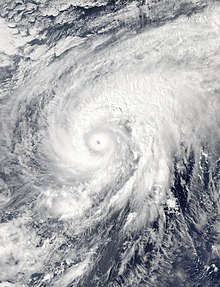
 Typhoon Nuri at peak intensity on November 3 | |
| Meteorological history | |
|---|---|
| Formed | October 30, 2014 |
| Extratropical | November 6, 2014 |
| Dissipated | November 7, 2014 |
| Violent typhoon | |
| 10-minute sustained (JMA) | |
| Highest winds | 205 km/h (125 mph) |
| Lowest pressure | 910 hPa (mbar); 26.87 inHg |
| Category 5-equivalent super typhoon | |
| 1-minute sustained (SSHWS/JTWC) | |
| Highest winds | 285 km/h (180 mph) |
| Lowest pressure | 907 hPa (mbar); 26.78 inHg |
| Overall effects | |
| Fatalities | None |
| Damage | Minimal |
| Areas affected | Japan |
| IBTrACS | |
Part of the 2014 Pacific typhoon season | |
Typhoon Nuri, known in the Philippines as Super Typhoon Paeng, was the third most intense tropical cyclone worldwide in 2014. Nuri developed into a tropical storm and received the name Paeng from the PAGASA on October 31, before it intensified into a typhoon on the next day.[1][2] Under excellent conditions, especially the synoptic scale outflow, Nuri underwent rapid deepening and reached its peak intensity on November 2, forming a round eye in a symmetric Central dense overcast (CDO).[3][4] Having maintained the impressive structure for over one day, the typhoon began to weaken on November 4, with a cloud-filled eye.[5]
Because of increasing vertical wind shear from the mid-latitude westerlies, Nuri lost the eye on November 5, and deep convection continued to diminish.[6] The storm accelerated northeastward and completely became extratropical on November 6.[7] However, on November 7, Nuri's circulation split, and the new center absorbed the storm.[7][8]
- ^ Cite error: The named reference
rsmc3106was invoked but never defined (see the help page). - ^ Cite error: The named reference
pagasawas invoked but never defined (see the help page). - ^ Cite error: The named reference
rsmc_bestwas invoked but never defined (see the help page). - ^ Cite error: The named reference
jtwc_prog12was invoked but never defined (see the help page). - ^ Cite error: The named reference
jtwc_prog19was invoked but never defined (see the help page). - ^ Cite error: The named reference
jtwc_prog23was invoked but never defined (see the help page). - ^ a b "RSMC Tropical Cyclone Advisory 070000". Japan Meteorological Agency. Archived from the original on May 23, 2024. Retrieved November 7, 2014.
- ^ "Marine Weather Warning for GMDSS Metarea XI 2014-11-07T12:00:00Z". WIS Portal – GISC Tokyo. Japan Meteorological Agency. Retrieved November 26, 2014.