| Tyrifjorden | |
|---|---|
 | |
| Location | Buskerud, Norway |
| Coordinates | 60°2′N 10°8′E / 60.033°N 10.133°E |
| Type | fjord lake |
| Primary inflows | Begna, Henåa, Skjærdalselva, Sogna and Storelva |
| Primary outflows | Drammenselva |
| Catchment area | 9,898.81 km2 (3,821.95 sq mi) |
| Basin countries | Norway |
| Max. length | 26 km (16 mi) |
| Max. width | 10 km (6.2 mi) |
| Surface area | 138.56 km2 (53.50 sq mi) |
| Average depth | 95 m (312 ft) |
| Max. depth | 295 m (968 ft) |
| Water volume | 13.13 km3 (3.15 cu mi) |
| Shore length1 | 171.81 km (106.76 mi) |
| Surface elevation | 63 m (207 ft) |
| Islands | Frognøya, Storøya, Utøya |
| Settlements | Hønefoss |
| References | [1] |
| Official name | Nordre Tyrifjord Wetlands System |
| Designated | 18 March 1996 |
| Reference no. | 802[2] |
| 1 Shore length is not a well-defined measure. | |
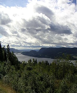
Tyrifjorden (Lake Tyri) is a lake in Norway. It lies 40 kilometres (25 mi) northwest of Oslo and is the nation's fifth largest lake with an area of 138.56 km2.[3] It has a volume of 13 km3, is 295 meters deep at its deepest, and lies 63 meters above sea level. The lake's primary source is the Begna river, which discharges into Tyrifjorden at Hønefoss where the river forms the waterfall of Hønefossen. Its primary outlet is at Vikersund near the lake's southwest corner, where Tyrifjorden discharges into the Drammenselva river.
- ^ Seppälä, Matti (2005), The Physical Geography of Fennoscandia, Oxford University Press, p. 145, ISBN 978-0-19-924590-1
- ^ "Nordre Tyrifjord Wetlands System". Ramsar Sites Information Service. Retrieved 25 April 2018.
- ^ "Statistisk årbok 2009: Geografisk oversikt" (in Norwegian). Ssb.no. Retrieved 15 May 2019.

