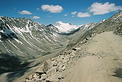


U-shaped valleys, also called trough valleys or glacial troughs, are formed by the process of glaciation. They are characteristic of mountain glaciation in particular.[1] They have a characteristic U shape in cross-section, with steep, straight sides and a flat or rounded bottom (by contrast, valleys carved by rivers tend to be V-shaped in cross-section). Glaciated valleys are formed when a glacier travels across and down a slope, carving the valley by the action of scouring.[2] When the ice recedes or thaws, the valley remains, often littered with small boulders that were transported within the ice, called glacial till or glacial erratic.
Examples of U-shaped valleys are found in mountainous regions throughout the world including the Andes, Alps, Caucasus Mountains, Himalaya, Rocky Mountains, New Zealand and the Scandinavian Mountains. They are found also in other major European mountains including the Carpathian Mountains, the Pyrenees, the Rila and Pirin mountains in Bulgaria, and the Scottish Highlands. A classic glacial trough is in Glacier National Park in Montana, USA in which the St. Mary River runs. Another well-known U-shaped valley is the Nant Ffrancon valley in Snowdonia, Wales.
When a U-shaped valley extends into saltwater, becoming an inlet of the sea, it is called a fjord, from the Norwegian word for these features that are common in Norway. Outside of Norway, a classic U-shaped valley that is also a fjord is the Western Brook Pond Fjord in Gros Morne National Park in Newfoundland, Canada.
- ^ "glacial valley | geological formation". Encyclopedia Britannica. Retrieved 2017-05-23.
- ^ "Glacial Trough/U-Shaped Valley". Illustrated Glossary of Alpine Glacial Landforms. Department of Geography, Central Michigan University. Archived from the original on 27 September 2020. Retrieved 8 August 2019.