| Ukelayat Range | |
|---|---|
| хребет Укэлаят | |
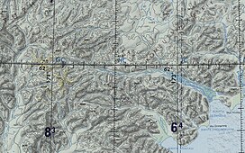
 The range stretching south of the Ukelayat river valley | |
| Highest point | |
| Peak | Ledyanaya |
| Elevation | 2,562 m (8,406 ft)[1] |
| Coordinates | 61°53′18.60″N 171°10′12.72″E / 61.8885000°N 171.1702000°E |
| Dimensions | |
| Length | 150 km (93 mi) E/W |
| Width | 40 km (25 mi) N/S |
| Geography | |
| Location | Kamchatka Krai, Russia |
| Range coordinates | 61°45′N 171°20′E / 61.750°N 171.333°E |
| Parent range | Koryak Highlands East Siberian Mountains |
| Geology | |
| Orogeny | Alpine orogeny |
| Climbing | |
| Easiest route | From Khatyrka |
The Ukelayat Range (Russian: хребет Укэлаят)[2] is a range of mountains in Kamchatka Krai, Russian Far East. The range is part of the Koryak Highland system and administratively it belongs to Olyutorsky District.[3]
The name of the range comes from the Koryak "vukvylgayat" (Вуквылгаят), meaning "rock/fall".[4]
- ^ Рундквист Н. Каприз блуждающего пальца. Корякское нагорье // Широко шагая. — Екатеринбург: Квист, 2014. — 576 с.
- ^ Cite error: The named reference
NARwas invoked but never defined (see the help page). - ^ Google Earth
- ^ Leontiev V.V., Novikova K.A. Toponymic dictionary of the North-East of the USSR / scientific. ed. G. A. Menovshchikov; FEB AS USSR . North-East complex. Research Institute. Lab. archeology, history and ethnography. - Magadan: Magadan . book. publishing house, 1989. - S. 290. - 456 p. — ISBN 5-7581-0044-7 .

