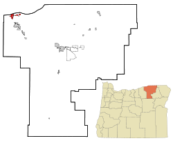
Umatilla, Oregon | |
|---|---|
City | |
 Umatilla Marina, Umatilla Bridge, and McNary Dam | |
| Motto: Catch the vision | |
 Location in Oregon | |
| Coordinates: 45°55′20″N 119°15′37″W / 45.92222°N 119.26028°W | |
| Country | United States |
| State | Oregon |
| County | Umatilla |
| Incorporated | 1864 |
| Area | |
| • Total | 5.08 sq mi (13.16 km2) |
| • Land | 4.99 sq mi (12.92 km2) |
| • Water | 0.10 sq mi (0.25 km2) |
| Elevation | 512 ft (156 m) |
| Population | |
| • Total | 7,363 |
| • Density | 1,476.44/sq mi (570.10/km2) |
| Time zone | UTC-8 (Pacific) |
| • Summer (DST) | UTC-7 (Pacific) |
| ZIP code | 97882 |
| Area code | 541 |
| FIPS code | 41-75650[4] |
| GNIS feature ID | 2412127[2] |
| Website | www.umatilla-city.org |
Umatilla (/ˌjuməˈtɪlə/, YOO-mə-TIL-ə) is a city in Umatilla County, Oregon, United States. The population in 2010 was 6,906, but the city's population includes approximately 2,000 inmates incarcerated at Two Rivers Correctional Institution.[5]
Umatilla is part of the Hermiston-Pendleton Micropolitan Statistical Area, but has the highest poverty rate (24%) and lowest Median Household Income ($38,796), of all communities in the area; trailing neighboring Hermiston in household income by nearly 23%.[6]
The city is on the south side of the Columbia River along U.S. Route 730 and I-82. The Umatilla Chemical Depot, is 6 miles (10 km) southwest of the city, northwest of the intersection of I-84 and I-82.
- ^ "ArcGIS REST Services Directory". United States Census Bureau. Retrieved October 12, 2022.
- ^ a b U.S. Geological Survey Geographic Names Information System: Umatilla, Oregon
- ^ Cite error: The named reference
USCensusDecennial2020CenPopScriptOnlywas invoked but never defined (see the help page). - ^ Cite error: The named reference
wwwcensusgovwas invoked but never defined (see the help page). - ^ "U.S. Census website".
- ^ "U.S. Census website". Retrieved May 26, 2019.