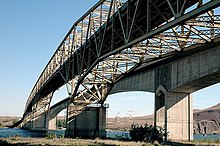
Umatilla Bridge | |
|---|---|
 Looking north from Oregon; older bridge in the foreground | |
| Coordinates | 45°55′52″N 119°19′41″W / 45.931°N 119.328°W |
| Carries | |
| Crosses | Columbia River |
| Locale | Benton County, Washington – Umatilla County, Oregon |
| Official name | Interstate 82 Columbia River Bridge |
| Maintained by | Washington State Department of Transportation[1] |
| Characteristics | |
| Design | Through truss cantilever bridge (southbound) Arch bridge (northbound) |
| Material | Steel (southbound) Concrete (northbound) |
| Total length | 3,308 ft (1,008.3 m) (southbound) 3,433 ft (1,046.4 m) (northbound) |
| Width | 27.58 ft (8.4 m) (southbound) |
| Longest span | 600 ft (182.9 m) (southbound) |
| No. of spans | 5 (southbound) 2 (northbound) |
| Clearance above | 16 ft (4.9 m) (southbound) |
| Clearance below | 85 ft (25.9 m) (southbound) 80 ft (24.4 m) (northbound) |
| History | |
| Opened | July 15, 1955 (southbound) 1988 (northbound) |
| Statistics | |
| Daily traffic | 10,800 (2017)[2] |
| Location | |
 | |
The Umatilla Bridge is the collective name for a pair of bridges in the northwest United States, carrying Interstate 82/U.S. Route 395 (I-82/US 395) across the Columbia River at the Washington–Oregon border. The older bridge opened in July 1955 and is a steel through truss cantilever bridge and carries southbound (east on I-82) traffic. Northbound traffic (west on I-82) and pedestrians travel on the newer concrete arch bridge, opened in 1988.
- ^ "Asset Management: Bridge Assessment Annual Report" (PDF). The Gray Notebook (34). Washington State Department of Transportation: 20. August 20, 2009. Retrieved December 26, 2023.
- ^ "I-82 (HWY 070) WB over COLUMBIA RIVER". BridgeReports.com. Retrieved January 5, 2023.