| Undyulyung Yakut: Үндүлүҥ | |
|---|---|
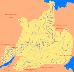
 Basin of the Lena with the Undyulyung in the upper right | |
Mouth location in Yakutia, Russia | |
| Location | |
| Country | Russia |
| Physical characteristics | |
| Source | |
| • location | Orulgan Range Verkhoyansk Range |
| • coordinates | 65°57′47″N 128°29′36″E / 65.96306°N 128.49333°E |
| Mouth | Lena |
• coordinates | 66°14′10″N 123°50′05″E / 66.23611°N 123.83472°E |
| Length | 414 km (257 mi) |
| Basin size | 12,800 km2 (4,900 sq mi) |
| Discharge | |
| • average | 135 m3/s (4,800 cu ft/s) |
| Basin features | |
| Progression | Lena→ Laptev Sea |
The Undyulyung (‹See Tfd›Russian: Ундюлюнг; Yakut: Үндүлүҥ, Ündülüŋ) is a river in Sakha Republic (Yakutia), Russia. It is the 19th longest tributary of the Lena, with a length of 414 kilometres (257 mi) and a drainage basin area of 12,800 square kilometres (4,900 sq mi).[1] There are no settlements close to the river.
A great number of fish species are found in the waters of the Undyulyung, including lenok, taimen, whitefish, perch, grayling, pike, ide, as well as the endangered Lena sturgeon. The river is a suitable destination for rafting.[2]
- ^ "Река Ундюлюнг in the State Water Register of Russia". textual.ru (in Russian).
- ^ Water of Russia - Ундюлюнг
