This article needs additional citations for verification. (May 2017) |
Uozu
魚津市 | |
|---|---|
 Top-Tateyama Mountains 1st row: Tatemon Festival, Ariso Dome 2nd row:Mirage Land, Buried Forest 3rd row:Uozu Aquarium, Uozu Station bottom:Mirage | |
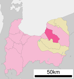
 Location of Uozu in Toyama Prefecture | |
| Coordinates: 36°49′38.3″N 137°24′33″E / 36.827306°N 137.40917°E | |
| Country | Japan |
| Region | Chūbu (Kōshin'etsu) |
| Prefecture | Toyama |
| First official recorded | 701 AD |
| City Settled | April 1, 1952 |
| Area | |
| • Total | 200.61 km2 (77.46 sq mi) |
| Population (1 March 2016) | |
| • Total | 42,224 |
| • Density | 210/km2 (550/sq mi) |
| Time zone | UTC+9 (Japan Standard Time) |
| Phone number | 0765-23-1067 |
| Address | 1-10-1 Shakadō, Uozu-shi, Toyama-ken 937-8555 |
| Climate | Cfa |
| Website | www |
| Symbols | |
| Flower | Lilium speciosum, Azalea |
| Tree | Pinus |


Uozu (魚津市, Uozu-shi) is a city in the eastern part of Toyama Prefecture, Japan. As of 1 March 2018[update], the city had an estimated population of 42,224 in 16,811 households[1] and a population density of 210 persons per km2. Its total area was 200.61 square kilometres (77.46 sq mi).[2]
- ^ Official statistics(in Japanese)
- ^ Uozu city introduction(in Japanese)


