| Upper Kolyma Highlands | |
|---|---|
| Верхнеколымское нагорье | |
 View of sparse larch forest in the highlands | |
| Highest point | |
| Peak | Gora Snezhnaya |
| Elevation | 2,293 m (7,523 ft) |
| Coordinates | 61°59′01″N 149°19′54″E / 61.98361°N 149.33167°E |
| Geography | |
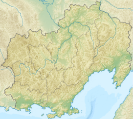
Location in Magadan Oblast, Russia | |
| Country | Russia |
| Federal subject | Magadan Oblast |
| Range coordinates | 62°55′N 146°50′E / 62.917°N 146.833°E |
| Parent range | East Siberian System |
| Geology | |
| Rock age(s) | Permian and Triassic |
| Rock type(s) | Sandstone, shale and granite intrusions |
The Upper Kolyma Highlands (Russian: Верхнеколымское нагорье, romanized: Verkhnekolymskoye Nagorye) is a highland area in Magadan Oblast, Far Eastern Federal District, Russia. The biggest town in the highlands is Susuman.[1][2]
There are large deposits of gold, tin and rare metals in the Upper Kolyma Highlands. The area is relatively less desolate than other mountainous zones of Northeastern Siberia, such as the Yukaghir Highlands or the Nera Plateau. However, some of the mining operations were deemed unprofitable following the collapse of the USSR and certain settlements of the Susumansky District lost population. Only a residual population remains in Shiroky, Kholodny and Bolshevik. Other places such as Belichan and Kadykchan have become ghost towns.[3][4]
The R504 Kolyma Highway crosses the southern part of the highlands.[2]
- ^ Верхнеколымское нагорье
- ^ a b Cite error: The named reference
GЕwas invoked but never defined (see the help page). - ^ Russian Federal State Statistics Service (2011). Всероссийская перепись населения 2010 года. Том 1 [2010 All-Russian Population Census, vol. 1]. Всероссийская перепись населения 2010 года [2010 All-Russia Population Census] (in Russian). Federal State Statistics Service.
- ^ Cite error: The named reference
GSЕwas invoked but never defined (see the help page).
