Upper Macungie Township | |
|---|---|
 Township sign in Breinigsville in March 2014 | |
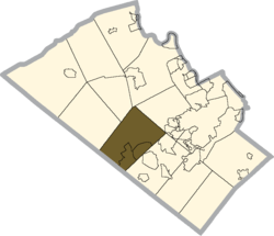
 Location of Upper Macungie Township in Lehigh County, Pennsylvania | |
Location of Upper Macungie Township in Pennsylvania | |
| Coordinates: 40°34′46″N 75°37′00″W / 40.57944°N 75.61667°W | |
| Country | |
| State | |
| County | Lehigh |
| Area | |
| • Township | 26.26 sq mi (68.02 km2) |
| • Land | 26.07 sq mi (67.53 km2) |
| • Water | 0.19 sq mi (0.49 km2) |
| Elevation | 463 ft (141 m) |
| Population | |
| • Township | 26,377 |
| • Estimate (July 2022)[3] | 27,875 |
| • Density | 1,011.0/sq mi (353.70/km2) |
| • Metro | 865,310 (US: 68th) |
| Time zone | UTC-5 (EST) |
| • Summer (DST) | UTC-4 (EDT) |
| ZIP Codes | 18031, 18051, 18087, 18104, and 18106 |
| Area code(s) | 610 and 484 |
| FIPS code | 42-077-79104 |
| Primary airport | Lehigh Valley International Airport |
| Major hospital | Lehigh Valley Hospital–Cedar Crest |
| School district | Parkland |
| Website | www |
Upper Macungie Township is a township in Lehigh County, Pennsylvania, United States. The population of Upper Macungie Township was 26,377 as of the 2020 U.S. census,[2] making it the fourth-fastest growing municipality of any category in Pennsylvania in terms of total population growth between 2010 and 2020.
The township was created in 1832 when Macungie Township was divided into Upper and Lower Macungie townships. It is part of the Lehigh Valley metropolitan area, which had a population of 861,899 and was the 68th-most populous metropolitan area in the U.S. as of the 2020 census.
Upper Macungie Township is located 11.5 miles (18.5 km) southwest of Allentown, 60.8 miles (97.8 km) northwest of Philadelphia, and 99.2 miles (159.6 km) west of New York City.[4]
- ^ "2016 U.S. Gazetteer Files". United States Census Bureau. Retrieved August 14, 2017.
- ^ a b "Total Population: 2010 Census DEC Summary File 1 (P1), Upper Macungie township, Lehigh County, Pennsylvania". data.census.gov. U.S. Census Bureau. Retrieved October 21, 2020.
- ^ https://www.census.gov/quickfacts/uppermacungietownshiplehighcountypennsylvania.
{{cite web}}: Missing or empty|title=(help) - ^ "The Official Borough of Emmaus Pennsylvania". borough.emmaus.pa.us. Retrieved December 20, 2016.


