Upper Marlboro, Maryland | |
|---|---|
| Town of Upper Marlboro | |
 The Upper Marlboro courthouse under renovation in 2008. | |
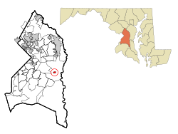
 Location of Upper Marlboro, Maryland | |
| Coordinates: 38°48′59″N 76°45′12″W / 38.81639°N 76.75333°W | |
| Country | |
| State | |
| County | Prince George's |
| Settled | 1695 |
| Established | 1706 (as Marlborough Town) |
| Replatted | 1744 (as Upper Marlborough) |
| Incorporated | 1870[1] |
| Founded by | Kingdom of England |
| Named for | John Churchill, 1st Duke of Marlborough |
| Government | |
| • Type | Commission[2] |
| Area | |
| • Total | 0.74 sq mi (1.91 km2) |
| • Land | 0.69 sq mi (1.79 km2) |
| • Water | 0.05 sq mi (0.12 km2) |
| Elevation | 23 ft (7 m) |
| Population (2020) | |
| • Total | 652 |
| • Density | 946.30/sq mi (365.17/km2) |
| Time zone | UTC-5 (Eastern (EST)) |
| • Summer (DST) | UTC-4 (EDT) |
| ZIP Codes | 20772, 20773, 20792 |
| Area codes | 301, 240 |
| FIPS code | 24-79875 |
| GNIS feature ID | 0598208 |
| Website | www |
Upper Marlboro, officially the Town of Upper Marlboro, is the county seat of Prince George's County, Maryland, United States.[4] As of the 2020 census, the population within the town limits was 652,[5] although Greater Upper Marlboro, which covers a large area outside the town limits, is many times larger.
- ^ "Upper Marlboro". Maryland Manual. Retrieved June 27, 2017.
- ^ "Town Government". Town of Upper Marlboro.
- ^ "2020 U.S. Gazetteer Files". United States Census Bureau. Retrieved April 26, 2022.
- ^ "Upper Marlboro". Geographic Names Information System. United States Geological Survey, United States Department of the Interior.
- ^ "Upper Marlboro town, Maryland". United States Census Bureau. Retrieved April 15, 2022.

