| Upper Truckee River Lake Stream, Lake Valley Creek, Little Truckee River[1] | |
|---|---|
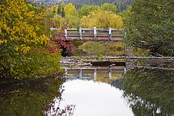
 Upper Truckee River, October 2010 | |
 | |
| Etymology | Named after the Paiute chief Truckee |
| Location | |
| Country | United States |
| State | California |
| Cities | Meyers, California, South Lake Tahoe, California |
| Physical characteristics | |
| Source | Red Lake Peak |
| • location | Sierra Nevada, Alpine County, California |
| • coordinates | 38°43′06″N 119°59′21″W / 38.71833°N 119.98917°W[2] |
| • elevation | 9,480 ft (2,890 m)[3] |
| Mouth | Lake Tahoe |
• location | El Dorado County, California |
• coordinates | 38°56′32″N 119°59′46″W / 38.94222°N 119.99611°W[2] |
• elevation | 6,224 ft (1,897 m)[2] |
| Basin features | |
| Tributaries | |
| • left | Echo Creek, Angora Creek |
| • right | Grass Lake Creek, Trout Creek (Lake Tahoe) (historically) |
The Upper Truckee River is a stream that flows northward from the western slope of Red Lake Peak in Alpine County, California to Lake Tahoe via the Truckee Marsh in South Lake Tahoe, California. The river flows northeasterly and is 23 miles (37 km) long.[3] It is Lake Tahoe's largest tributary.[4]
- ^ Barbara Lekisch (1988). Tahoe Place Names: The Origin and History of Names in the Lake Tahoe Basin. Great West Books. pp. 144–145. ISBN 9780944220016. Retrieved December 28, 2012.
- ^ a b c "Upper Truckee River". Geographic Names Information System. United States Geological Survey, United States Department of the Interior.
- ^ a b "National Hydrography Dataset high-resolution flowline data". The National Map. U.S. Geological Survey. Retrieved December 28, 2012.
- ^ "Tahoe: State of the Lake Report 2016" (PDF). UC Davis Tahoe Environmental Research Center. p. 17.